-
Pedal the Peaks Spring 2008 - June 1 - Day 2 - Redinger Lake Loop
I was up at 6:30. Ann decided to cook breakfast for herself in the room. I sat with Bob and Mick from Benicia in Ducey's. Dennis joined us a few minutes later. I wasn't as hungry this morning so I had orange juice, coffee and oatmeal with brown sugar.
We started riding around 9:15. Our day was planned to be around 55 hilly miles. This was much less than Day 1 so I wasn't too unhappy about the starting time. We left going north on North Shore Drive. This road is next to the lake and goes past many summer and permanent homes. After a mile or so, we made a sharp left onto Road 222. There were a few sore legs from yesterday, so the pace was reasonably slow. I was even in the front for awhile. The weather was warm already. I had on my shorts, arm warmers and no undershirt - I learned my lesson the day before.
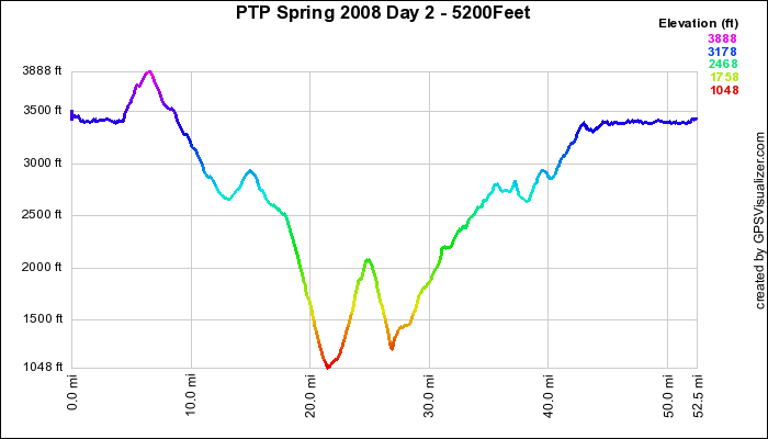
After another couple of miles, we turned right at "The Forks" onto Road 426 (Crane Valley Road) and then left on Road 223. Climbing began at "The Forks". We reached the peak of the climb after 400 feet and 7 miles. Then we had a nice downhill of 1300 feet, a slight uphill, and then another downhill at North Fork for 6 miles with a drop of 1900 feet on Road 222. This took us down to the San Joaquin River at 1050 feet. I had made a couple of quick stops before this, so the faster group was not in sight. I did catch a couple of other riders that had passed me while I was in the bushes.
We turned left on Road 235, Redinger Lake Road, and the serious climbs of the day started. I don't think that this road has ever seen pavement. The surface was similar to chip seal but instead of gravel, they used stones. It was pretty rough although the climbing minimize the poor surface. It was getting pretty warm, so I hydrated with plenty of water and refueled with a energy bar. I took off my arm warmers, too. We climbed around 1100 feet in 4 miles, about the same as Tunnnel Road from my house which is a fairly easy climb. The difference in this ride was the road surface and many steep pitches.
After reaching the summit, we had a 2 mile downhill where we lost almost all of the altitude that we gained before. We couldn't get up to speed because of the poor road surface, but it was nice to go downhill for a rest. After a short, steep little wall, we arrived at Redinger Lake, our lunch stop. A few of the riders beat me there. I was about in the middle of the pack. We congregated under the shade of a lone tree and waited for the rest of the riders and Dennis with the lunch. When Dennis got there, we discovered that some of the riders opted out of the full ride today because of various reasons.
I was much hungrier today than yesterday, so I could eat my normal mid-ride lunch of PB and J along with some salty chips and cranberry juice. The lunch stop was advertized as being a swimming stop, too. Only fast Bob went in. He also waited around when we were finished eating to help Dennis clean up. He broke a spoke on the rough downhill, so he was done for the day.
The next 14 miles were mostly uphill and mostly on the rough road. After we left the lake, we turned left on Road 235 and climbed our way for 1800 feet through South Fork and then into North Fork on better pavement. My legs and arthritic toes were starting to bother me, so I hopped into the sag along with several others at mile 40 and took a free ride for 4 miles and 600 feet of elevation gain.
What a difference that made! I breezed the last level 9 miles on the west shore of Bass Lake and on into The Pines. This part of the route was very scenic. The lake was on my right and the forest was on my left. There were lots of summer homes along the way and many families playing in the water. Although the road was narrow, very little traffic made it even nicer.
I pulled into the resort at 2:00, found our car, put my bicycle away, got out my change of clothes and took a shower in Dennis' room. After hydrating and eating some snacks, Ann and I said our farewells and left for home.
My daily statistics were 49 miles, 4500 feet elevation gain, average speed of 12.7, maximum speed of 39.9. The whole route was 53 miles with 5200 feet elevation gain.
The drive home was even better than the drive to Bass Lake. Nuvi took us on lightly traveled back roads again. When we got to the freeways, there wasn't much traffic either. By the time we reached Dublin, the car was thirsty and we were hungry. We had dinner at the Dublin Sports Pub. Then we quenched our car's thirst and drove to Benicia to pick up KD. We made it home around 8:30.

Elevation Profile - Click to Enlarge
Garmin GPS Google Earth
 Bob on Pedal the
Peaks Spring 2008

