-
Pedal the Peaks Spring 2008 - May 31 - Day 1 - Scenic Byway Loop
I was up at 6:30. Ann and I went to breakfast at Ducey's at 7:00 or so. I wanted to get plenty to eat including lots of protein for the hard ride ahead. So I had scrambled eggs, hash browns, bacon and toast along with orange juice and coffee. Dennis sat with us. We saw almost all of the other riders having breakfast at the same time.
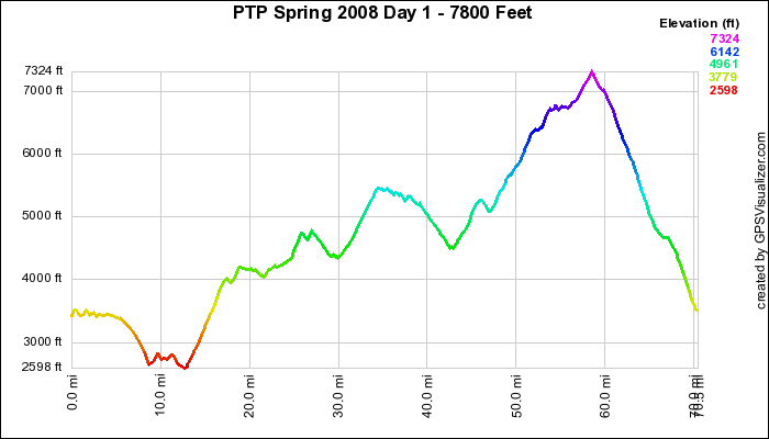
We started riding at 9:25. Our day was planned to be around 75 very hilly miles, so this was a little late for me to get going. I would have preferred about an hour earlier. Anyway, we rolled out up the short, steep hill from the resort and turned right on Road 274, Malum Ridge Road. The road was above the lake with dense forests on each side. There were a few rollers before we dropped down from 3500 feet to 2600 feet at North Fork after 9 miles. I was able to keep up with the front group because everyone was pedaling easily and keeping a social pace. The weather was sunny and warm enough for me to ride in shorts and arm warmers. I also had on a undershirt to keep warm in the shady sections and the descents.
We turned left at North Fork onto Road 225 - Mammoth Pool Road also know as the Scenic Byway - and started a sharp ascent. I started to fall back slightly here. There were some very strong riders at the front. Some of them - Bob, Jeff and Sharon - were joined by riders wearing Death Ride, PBP and Webcore jerseys. I was a little intimadated but not embarassed. We continued on some rollers for 4-5 miles at which point we started to climb. By this time I was riding alone, occasionally passing or being passed by a rider or two. The road was fairly open and the sun was beating down. At about 3200 feet, I was getting very warm. So I stopped on the side of the road, took some photos of the vista and stripped off my undershirt and arm warmers. The view from here was gorgeous. I could look down through the oak trees onto Redinger Lake and the valley the was formed by the San Jaoquin River.
After this brief rest, I began climbing again. There were a few level spots, but it was uphill most of the way to our official lunch stop. The vistas were still magnificant, but they were hidden at times by the topography of the roadway. The area below us is know as the Mommoth Pools. It's a busy tourist area, but it hadn't opened for the tourist season yet. We were lucky because it shut down the traffic. Our lunch spot was at "Mile-High Vista". As I trudged up the hill, I kept watching my altimeter to see how far I had to go. I was getting disheartened when I passed 5280 feet and I didn't see the sag. Then at 5400 feet I saw a sign for "Mile-High Curve" and I knew I was close. I rolled into "Mile-High Vista" about 1/3 mile farther at 12:40. Lots of the riders were there already. The vista from here was incredible. You could see the Mommoth Pools a few thousand feet below and along the horizon you could see the snow-topped Sierras including the Minarets, Mt. Ritter (13,157'), Mammoth Mountain, and at least fifteen other named peaks over 10,000.
I was not in very good shape at this point in the ride. My legs were very tired, my arthritic toes hurt and I wasn't hungry. This last fact warned me that I was in trouble. I feel this way from time-to-time when I am riding at high altitude. I don't think it is altitude sickness but it's close. I decided that the additional 3000 feet of climbing and 30 miles to the summit would be too much. After all but three of us left the lunch stop, we helped Dennis load the sag with the lunch supplies, our bicycles and ourselves. Then we rode in the sag up to the summit. I was sorry that I passed up this part of the ride because the landscape became very alpine with lots of pine trees and other evergreens. Grizzly Road was especially nice - narrow, shady and picturesque. It smelled good, too. A lot of the route today is part of the Grizzly Century.
At lunch, Dennis warned the riders that there were some tricky turns ahead and to be alert when they got to them. Everyone made the correct turns except Sharon. Although someone yelled at her at her miscue, she eventually turned around but missed the turn on the scheduled route and ended up riding back to Bass Lake retracing our morning route. We passed the other riders heading up Grizzly Road, stopping from time-to-time to give them water and food. At the top of Grizzly Road, we made a left turn onto Beasore Road. After driving a mile or so, we ran into a deep snow drift that covered the roadway. There was no way that the van could get through. In fact a couple of riders that had gone ahead and circled back told us that there were several more drifts on the roadway. So it was time for me and the other two saggers, Chuck and Frank, to get out of the van and get riding again.
For a mile or so, I wouldn't call it riding. We had to carry our bicycles over about a dozen deep snow drifts. I had on cycling sandals, so my socks got wet. If we pushed our bikes through the snow, the pedals and brakes got clogged up with slush and pine needles. Our cleats were packed with ice, too. We prevailed, though, and got up to Cold Creek Summit. We were to begin a 14-mile, 4000 foot descent back to Bass Lake. However, we had another few drifts to get through first. A couple of drifts had tracks through them down to the pavement, so we could carefully ride through them. Two riders went down, both in the slush so they weren't hurt. I saw one rider slip in the deep slush and go down. Mick said that he tried to ride through some shallow slush and didn't make it. The long downhill was worth it, though. There was some debris on the road so we couldn't go at top speed. It was still a quick descent going from the very cool summit to warm Bass Lake. I got back at 4:30.
My final statistics were 50 miles, 5000 feet of elevation gain, 12.4 MPH average speed and 39.8 maximum speed. The whole ride was 78 miles and 7800 feet of altitude gain.
Dennis wanted to get us all to dinner together, but cyclists are as difficult to herd as cats. Ann and I along with six others ended up at a forgetable Mexican restaurant. The marquaritas were good but the fish tacos were pretty bland. The other riders ended up at Ducey's.
After going back to our room, I tried to read but kept falling asleep. So it was bedtime at 9:30

Elevation Profile - Click to Enlarge
Garmin GPS Google Earth
 Bob on Pedal the
Peaks Spring 2008


