-
October 22 - Bodfish to Bakersfield

View on Breckenridge Road

View on Breckenridge Road

Autumn Leaves on Breckenridge Road

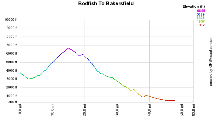
The Day's Elevation Profile
Please visit October 22 slideshow.
Day 4 started out cool and sunny. The ride was scheduled to start at the top of the hill past Bodfish. The stronger riders decided to start in Kernville for additional miles and more climbing. Many of us took the sag to the top of the hill. We had a good downhill when we started riding, but we didn't deserve it.
After the downhill, we started a gradual uphill. As we pedaled along, we noticed several signs alongside the road - "Grocery Store", "Hotel", etc. We were in the town of Havilah, an old mining community that is considered a ghost town but is now inhabited (if you can call it that) by retirees and ranchers.
In a mile or so from Havilah, we reached Breckenridge Rd, made a right turn onto it, crossed a cattle guard and began climbing. This was a climb of about 10 miles up to 6700 feet. It had wonderful vistas, varied landscape (bare to forested hillsides) and many false summits. Once we reached the top, we had a few flat areas but mostly downhills to the lunch stop at the side of the road. The road surface was a little broken and it had lots of leaves and pine needles on it. Needless to say, we were very cautious while we were descending.
I took sag duty after lunch and drove all of the way to the motel. The route was mostly downhill with a few intermediate climbs. It went from wooded hillsides to picturesque valleys to barren land. The last few miles were on city streets in Bakersfield to the motel.
After gathering our gear and changing our clothes, we thanked Dennis and said good-bye to those left in the parking lot. Steve, Jim, Rick and I got into Steve's car and began the ride back to the Bay Area. The highlight of our drive was stopping for dinner at Andersen's Pea Soup in Santa Nella. Steve dropped me off at Jim's house and he drove me to Lafayette BART. Ann picked me up at Rockridge and I was home before 10:00.
The daily statistics for me were 22 miles and 4000 feet of climbing.
The map of our route is below. To see it in Google Earth, follow this link.
 Bob on Pedal the Peaks
2007