-
Widget powered by EveryTrail: GPS Geotagging
Photos available at Smugmug
There is not much to say about today except rain, cold weather, a lot of climbing and getting lost. First of all, the rain. We started out with a heavy overcast that turned to intermittent misty rain. This wasn’t too bad when we were climbing, but it was pretty bothersome on the downhills. Especially when the temperature dropped to 10c (50f). We had to take it easy on the descents because of the danger of slippery roads. Right before we got to Todi, the skies opened up and we got very wet. Ted, Kathy and I were the only ones doing the long route today and we rode together. The others took a shortcut but they still got wet.
I mentioned the cold weather. It ranged from 10 – 17c but it was mostly in the 10-12 range. The only time I felt really cold was when we stopped. We stopped once in a small village for snacks where I started shivvering. Other than then it was OK. Lunch was in Marsciano where I had two slices of ready-made pizza. It wasn't very good, but I was hungry and it gave me enough energy to keep going.
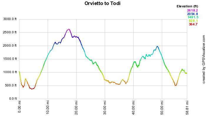
The route had lots of ups and downs. It was advertized as having 1500 meters (about 5000 feet) of climbing. We did that or more. I didn’t get the final statistics for elevation gain because the rain damaged my GPS. I waiting for it to dry out overnight to see if it still worked.
I started the day by missing one of the first turns. So I immediately tacked on 3 km and about 200 feet of climbing. Ted, Kathy and I were confused about some of the turns on the queue sheet. One was at Castello di Vibio an immaculately preserved hilltop village. The route map showed us going through the village and out the other side. We found this was not possible as we walked our bikes through the maze of narrow streets. We stopped a postman and got directions from him in Italian. That sent us back to our maps and my GPS. We finally got back on route and a beautiful route it was. We managed to go off-route again much later near a village named Doglio. After passing though the village, we began to climb through a forested ridge. The road became narrower and narrower and the pavement got worse and worse. When my GPS suggested that we make a hard left onto a dirt uphill, it was time for drastic action. While Kathy and I had some snacks (she gave me a Cliff Shot which really hit the spot), Ted got onto his Blackberry’s Google Map routing program and found us directions to Todi. My GPS was still working at that point, but it kept sending us to the wrong roads. It has something to do with rerouting using the waypoints on the original route. This is where we met the rain storm on a nice downhill. We sloshed our way into Todi.
We all had a good time, though. Snacks on the road, pizza for lunch and Cliff Shot to boost our energy late in the day. We arrived at Hotel Tuder in Todi at 5:10 with just enough time to clean up and get to happy hour.
Dinner was at the hotel. We started out with two pasta dishes – a light lasagna with truffles and spaghetti with a fresh tomato sauce. Our second course had two entrees – game hen with a liver and mushroom sauce and lamb backed with rosemary. Dessert was tiramisu.
I didn’t take many photos because the clouds and fog made the visibility poor.
Miles Max Speed Average Speed Moving Time Total Ascent Weather 57 29 11 5:26 5000 Feet Mist and rain mostly in the 50’s
Please take a simulated tour of the route.

Elevation Profile (Click to Enlarge)
 Bob on BAC
Umbria - Rome to Assisi 2009


